

Top Hikes in Norway
- Nov 17, 2017
- 9 min read
Before I begin this post, you should probably know something about Vince and I. We are hikers. We LOVE to hike. Whether it is a short meander, a gruelling few weeks (without showers) or wading through mud infested waters, we are down like clowns. If there is a good hike around, rain or shine we will do it or at least give it a crack. Now that you know that, you will understand that when I reminisce on this site about a hike, it is for a reason...that reason being that it was awesome.
During our 5 week road trip around Denmark, Sweden and Norway we came across some incredible walks and hikes. Nevertheless, Norway won our hiking hearts. If you want to see breathtaking sights, experience nature at its finest or challenge yourself a little, then Norway is the place for you.
Below I have outlined and included photos of our five favourite hikes we did while in b.e.autiful Norway (they are in no specific order).
1. Preikestolen (Pulpit Rock), Forsand, Rogaland County
If you have done any research at all about Norway, Preikestolen has probably popped up once or twice. Its popularity is due to two reasons. 1) It is awesome and 2) it is easily accessible. Whether it is sunny or cloudy, the views at the end of this trail are beautiful and dramatic. The day we went we where in the cloudy category. It rained the whole time we were walking...but that is what rain jackets are for. So if it is forecasted, bring one. As the Scots say: "there is no such thing as bad weather, only the wrong clothing".
We reached the lookout after about an hour or so and were lucky the rain stopped. This doesn't mean the clouds went away. As you can see in my pictures below it was definitely cloudy, however, this only added a haunting allure to the overall view. I have no regrets about completing this hike in the rain. If anything, it also meant there were fewer people. This hike is very popular among locals and tourists because it is an easy walk with only some steps. The stairs are about three quarters (¾) of the way through, so if you have problems climbing up and down boulder like stairs, then just be aware. These stairs also get quite slippery when it is raining, so proceed with caution. I will also just quickly say: be careful at the end when taking pictures. You don't have to be a high IQ Scientist to be cautious of your surroundings. There is no railing at the end, only an impressive slab of rock, so don't be ridiculous or put yourself at risk by doing handstands or hanging off the edge (no matter how awesome a shot it would be). Simply enjoy the view and your surroundings and try not to photobomb everyone there.

Time
Allow a total of 3 1/2 - 4 hours. Unless you are running. And it depends how much time you feel like spending at the end. Enjoy the view, you walked all the way there for it.
Difficulty
Easy - medium (all depends on mobility and level of fitness). We are healthy, fit and in our late 20s so we found it easy.
Distance
About 6km from Preikestolen mountain lodge.
Ascent
350m (that means going up and down a bit). The beginning of the hike is spent mostly going up but then it levels out for a bit. The you have the boulder stairs towards the end.
Season
May - October
Landscape
Mountain area (rocky)
Fun to know
- It rises 604 metres above the Lysefjord
- The red T marks the route. So follow them.


The hike starts from the parking lot by the Preikestolen Mountain Lodge (Preikestolen Fjellstue). There’s a decent amount of parking, however it costs 100 NOK by cash or card. The Mountain lodge offers a hiking map, toilets, food and a small information centre.
We drove from Lysebotn, which was about a 3 hour drive. You can take a ferry instead over Lysefjord, but it is very expensive.
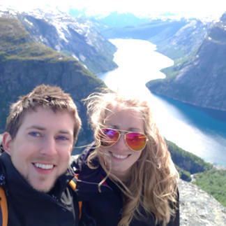
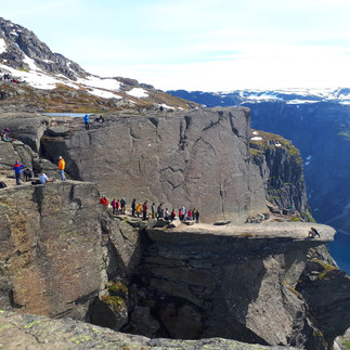
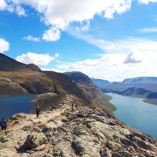
2. Trolltunga, Odda, Hordaland County
Trolltunga is listed on every hiking site in Norway for a reason. It is unbelievable. And the "trolls tongue" at the end makes for a spectacular shot. My greatest regret is not having an awesome camera, like always we were only equipped with my fancy Samsung Galaxy for photos...and they don't do it justice.

Off to a cloudy start we were later blessed with glorious sunshine. The colours were insanely vibrant. The whole hike is made up of spectacular views and it changes all the time.
We were there in late June and there was still quite a bit of snow around. Remember waterproof walking shows if you have them. I didn't and I spent the better part of the day walking around in soggy shoes. You can skirt around most of the melting snow, but there are spots you have to walk through it. Also, the hike is a long one, so make sure you bring plenty of snacks and water.


Time
10 - 12 hours return. It took us about 10. Again it depends how much time you spend at the end. There can sometimes be quite a lineup to take your picture on the "trolls tongue", you can only go a couple of people at a time for obvious safety reason. Most people wait there turn so that no one else is in the shot.
Difficulty
Medium - hard. We found it very doable. Just watch out for the slippery snow parts depending on what time you are there. We had a few slips here and there on downhill icy snow. So be careful.
Distance
22km there and back
Elevation gain
900 meters (2,950 feet)
Season
June 15 to September 15 (without a guide). At all other times of the year you must hike with a guide.
Landscape
Mountain area (rocky, snowy, icy)
3. Skageflå, Geiranger (Via Homlong), Stranda, Møre og Romsdal County
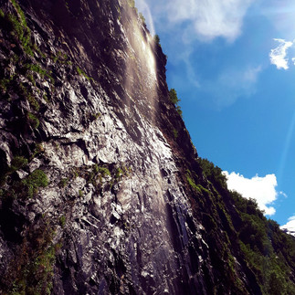
The intense blue of the Geirangerfjord is a spectacular sight to behold. This fjord is surrounded by soaring mountainsides and elegant waterfalls. There are a number of hikes to check out around here, a great list of them can be found on the Fjord Norway site:

On our own trip we decided to check out the Skageflå hike. The site of the Skageflå farm is unlike any farm I have ever seen. Perched on the edges of a cliff it overlooks the picturesque Seven Sisters Waterfall. There are two ways to get to the farm. You can hike from Geiranger to Skageflå on a round trip hike covering 12kms or you can take a water ferry to Skagehola and hike up to the farm making your way back to Geiranger.
Because we had a car we drove from Geiranger town over to Homlong Campsite, this is right next to the start of the trail and you can park your car for a small fee. The drive is only about 8 minutes, but saves you an extra 30 minute walk from town. From the very start the route is well marked with signs and spray-painted marks. Follow the path uphill and around the fjord. After arriving at Homlongsaetra, a gorgeous lookout and mini farm, continue following the fjord until you start descending towards Skageflå farm (you shouldn't be going upwards anymore). You will be going down quite a way, it is a mixture of boulder like steps, tree roots and mud, so be careful if it is wet. You will then reach a steeper part to descend with fixed ropes. It is all very easy, just take your time and don't rush.
If you are lucky with the weather like we were, make sure you give yourself enough time to just sit and enjoy the view. We spent about an hour lying in the grass with the sun on our faces. We had the whole place to ourselves and it was utterly peaceful.


Time
About 2 hours to Skageflå (took us about 3 and a half hours return with a 30 minute stop to enjoy a snack and the view).
Difficulty
Medium - hard (when descending)
Distance
About 5 km one way
Elevation gain
Skageflå - about 250m above fjord
Homolongsaetra - 550m above fjord
Season
January - December
Landscape
Mountainous, rocky & muddy
Fun to know
- These farms used to have to harness their children and animals with ropes so they would not fall of the edges of the cliff.
- Abandoned in 1916, it is now only a tourist attraction.
- Skageflå Farm is a UNESCO World Heritage Site.
Getting there by car
The Geirangerfjord is located around 3 hours by car from Ålesund.


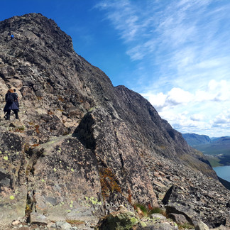
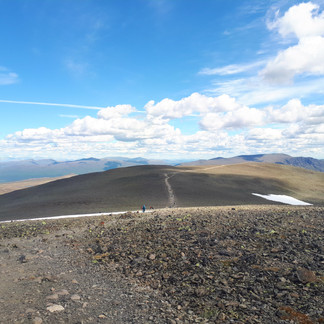
4. Besseggen Ridge (Jotunheimen National Park) Vågå Kommune, Oppland County

This hike was hands down one of the most memorable hikes we have ever done. We were completely enthralled. At all times we were surrounded by majestic mountains, the emerald waters of Gjende and the deep blue of Bessvatnet lake...and we even saw wild Reindeers!!! This was a long hike, so be prepared for the long amount of time that includes getting to the ferry, taking it over and hiking back. Water, food and warm clothing to protect you from the wind is essential.
There are a couple of ways to go about this route. You can either start with a ferry in the morning that takes you to the start of the hike and hike back to the town OR you can start the hike at the Ferry terminal and then when you reach the end of the route take a ferry back to the beginning. The first option is the easiest as you don't have to worry about getting to the last ferry in time.

We decided to start by taking the boat FROM Gjendesheim (the ferry terminal will come up as Gjendebåten on google maps) to Memurubu in the morning. As usual there is always a line for the ferry but if you book your ticket ahead of time you will be fine (you can book tickets when you get there but the line is nearly always long). We made sure we were there 40 minutes early.
Once you get off the short ferry ride at Memurubu, you start walking uphill. The route levels out after about half an hour, before it ascends again across rocky terrain, which will take about 2 hours before you reach the base of the ridge itself. This continues until the top of the ridge is reached, offering spectacular views of jagged peaks piercing the sky. After the peak, it is relatively relaxed with gentle slopes until you get towards the end when there are lots of boulder-like steps and pebbly slopes.


Time
6 - 9 hours
Difficulty
Medium - Hard (there are some moments of climbing/scrambling, you definitely have to walk with your hands out of your pockets). The steepest part is only 50m high and you get over it fairly quickly. Nevertheless we saw hikers of all ages, shapes and sizes and if you give yourself enough time then you can easily meander your way over.
Distance
About 13km
Elevation gain
The highest point of the hike is reached at Veslfjellet, 1,750 metres above sea level.
Season
June - mid September (Summer - Autumn). Keep in mind that there can often still be snow laying around. We were there in June and there were still patches of snow.
Landscape
Mountainous, stony, small pebbles
Good to know
- The path is well marked and mostly quite wide, with intermittent cairns marked with a red 'T'.
- Boat timetable: www.gjende.no
- If you are lucky you might spot a herd of reindeer. If you do see them, make sure not to get to close (even if they look adorable and fluffy).
- We saw parents carrying their toddlers in those fancy carrier backpacks and kids as young as 8 doing this hike.
- Parking cost at the ferry (100NOK).
- If there is no parking at the ferry, then you can park at a public parking spot with a toilet (it comes up as Long Term Parking for Gjendebåten on google maps and costs about 80NOK), from there it is a 20 min walk (1.8km). This is what we had to do, we jogged over to the ferry in the morning and crawled back to the car park when we finished the hike :)
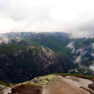
5. Kjerag, Forsand, Rogaland County
Last on this list is Kjerag. Now we did not get to complete this hike due to the weather. What started as a lovely day quickly turned so cloudy, windy and misty that we could barely see a metre in front of us. Despite our desire to reach the famous boulder, for caution sake we decided to head back before reaching the very end. Still, it was an awesome hike, with different views.

This hike felt very different from the others. Most of what we covered involved hiking over flat rock, even when you are on an incline. It felt like we were walking on a moonscape. Of course this means it can be very slippery when going down. There are chains in place for sections that involve steeper descents or minor scrambling.
You begin the hike from the carpark of Øygardstøl (Kjerag restaurant and lookout). Again, follow the Red T's.

Even though we did not complete the hike, here are the important facts:
Time
6 - 8 hours
Distance
12 km (7.5 miles)
Difficulty
Medium - Hard (there are chains in some of the steeper sections)
Elevation Gain
570 meters
Season
June - September (Summer)


Last thing i'll say, don't forget the most important rules about hiking:
* Don't leave ANY rubbish EVER...no excuse
* Always bring plenty of water (better to deal with a slightly heavier bag than to run out)
* Bring high energy snacks (just incase)
* Take the time to enjoy the views (if you are like me and rely on your phone for pictures, they might not always do it justice)
* Do it with a smile...even when the going gets tough, try to smile at least every 5 minutes. Trust me it helps.
Enjoy!
Thanks for reading. Have a sunshiny day 😀

Comments